
St. Martin Climate Impact Atlas
We worked together to develop a climate atlas for St. Martin
Customer
Location
Duration
Read more
International Panel on Deltas and Coastal Areas
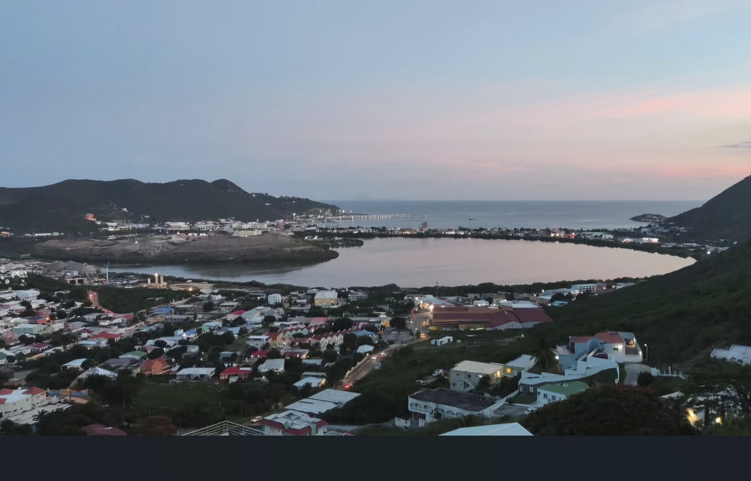
St. Martin
2025
St. Martin Climate Impact Atlas
We worked together to develop a climate atlas for St. Martin
Customer
Location
Duration
Read more
International Panel on Deltas and Coastal Areas
St. Martin
2025
To help St. Martin prepare for the impacts of climate change, we developed the St. Martin Climate Impact Atlas. We created it together with the Ministry of VROMI of Sint Maarten and the University of St. Martin (USM), commissioned by the International Panel on Deltas, Coasts and Islands (IPDC). The goal is to support governments, residents, communities, and other stakeholders in better understanding how climate change affects their area. This way, St. Martin can work toward becoming a more climate-resilient island in a fair, inclusive, and equitable way.
The island of St. Martin is divided into two autonomous territories: the Collectivité de Saint-Martin in the north (French) and the Country of Sint Maarten in the south (Dutch). Because climate change affects everyone on the island, the atlas takes a whole-island approach. Wherever possible, data and insights cover the entire island. The atlas is available in English, French, and Spanish.

Understanding climate risks
St. Martin faces several challenges caused by climate change. Coastal flooding, heavy rainfall, and rising heat threaten the island’s future, and hurricanes remain a constant risk. The St. Martin Climate Impact Atlas helps identify and understand these different climate risks. For example: Which areas are vulnerable to flooding? Where does it get extremely hot? And who is most at risk? The atlas provides insights into these questions. With this atlas, we aim to contribute to a lasting infrastructure of climate knowledge.
Why a Climate Impact Atlas for St. Martin?
Many organizations are already working to address the effects of climate change, but the available data is still limited, scattered, and often difficult to interpret. The St. Martin Climate Impact Atlas brings all available information and knowledge together in one central place, making it easier for different sectors and stakeholders to use.
The atlas is designed to be understandable for everyone, with clear map explanations and stories that make complex data more relatable. Its main goal is to create a shared understanding of climate risks and impacts.
What can you do with the atlas?
The St. Martin Climate Impact Atlas shows how climate change affects the island — both now and in the future. It includes maps, explanations, stories, a mind map of climate impacts, and key statistics.
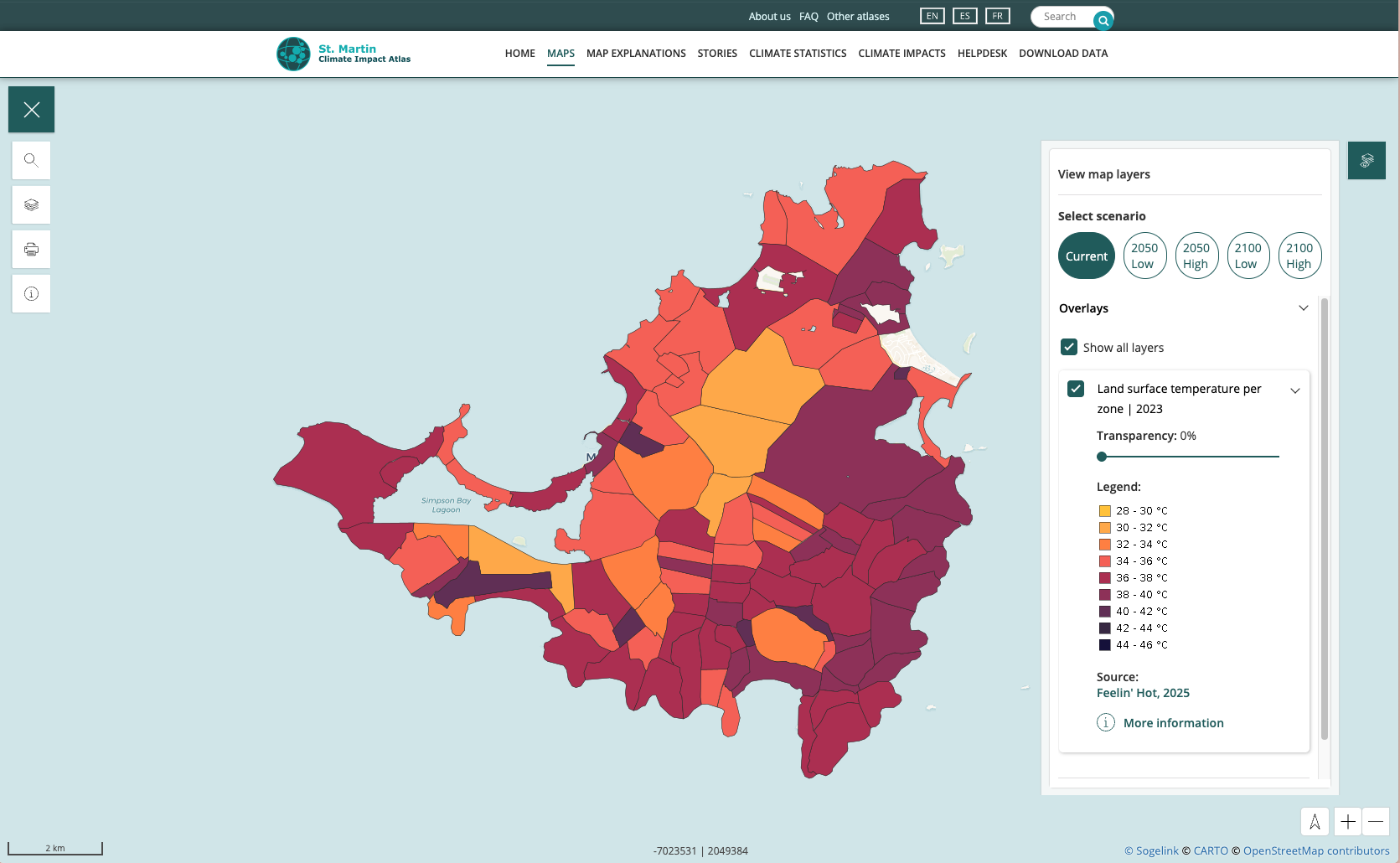
- Maps: In the map viewer, you can explore more than fifty different maps that show how climate change may affect different areas. You can view data on storms, flooding, drought, heat, and more. The base maps also provide useful background information, such as types of landscapes, important buildings, and districts.
- Map Explanations: The map explanations give background information about the most important maps. Topics include coral reefs, mangroves, past hurricane trajectories, future coastlines, and terrestrial biodiversity.
- Stories: The stories, written by St. Martin author and educator Rochelle Ward, bring the island’s climate challenges to life and highlight possible solutions. They reflect St. Martin’s culture and make the topic more relatable to its residents.
- Climate Impacts: The mind map gives an overview of the impacts of climate change on St. Martin, based on research and stakeholder workshops held in 2025.
- Climate Statistics: The statistics section helps you understand how climate change affects different themes and sectors. The data is based on information from the Department of Statistics Sint Maarten and the 2023 climate scenarios of the Royal Netherlands Meteorological Institute (KNMI).
Who contributed to the St. Martin Climate Impact Atlas?
The Climate Impact Atlas is the result of a unique collaboration between more than 20 organizations and individuals. Partners from both autonomous parts of the island, as well as several international organizations, worked together to make it possible.
The following organizations and individuals contributed to the development of the atlas: BirdLife International, Collectivité de Saint-Martin, Department of Statistics Sint Maarten, Environmental Protection In the Caribbean (EPIC), European Marine Observation and Data Network, Émilie Flamme, Rochelle Ward, Feelin’Hot, Grant Thornton (GT), Laëtitia Mathon, Meteorological Department of Sint Maarten (MDS), Nelen & Schuurmans (N&S), Nature Foundation Sint Maarten (NFSXM), NOAA, Ramsar, Réserve Naturelle Nationale de Saint-Martin (AGRNSM), Royal Netherlands Meteorological Institute (KNMI), Shom, Territorial Unit of Saint-Barthélémy and Saint-Martin of the Department of Environment, Development and Housing (French acronym: DEAL) Guadeloupe, UNESCO, and Vrije Universiteit Amsterdam (VU).
What are the next steps?
The Climate Impact Atlas will be used to support community discussions, develop a national adaptation strategy, and strengthen climate awareness across the island. Several projects are already underway to achieve these goals — some of which are supported by the IPDC.
Understanding climate risks
St. Martin faces several challenges caused by climate change. Coastal flooding, heavy rainfall, and rising heat threaten the island’s future, and hurricanes remain a constant risk. The St. Martin Climate Impact Atlas helps identify and understand these different climate risks. For example: Which areas are vulnerable to flooding? Where does it get extremely hot? And who is most at risk? The atlas provides insights into these questions. With this atlas, we aim to contribute to a lasting infrastructure of climate knowledge.
Why a Climate Impact Atlas for St. Martin?
Many organizations are already working to address the effects of climate change, but the available data is still limited, scattered, and often difficult to interpret. The St. Martin Climate Impact Atlas brings all available information and knowledge together in one central place, making it easier for different sectors and stakeholders to use.
The atlas is designed to be understandable for everyone, with clear map explanations and stories that make complex data more relatable. Its main goal is to create a shared understanding of climate risks and impacts.
What can you do with the atlas?
The St. Martin Climate Impact Atlas shows how climate change affects the island — both now and in the future. It includes maps, explanations, stories, a mind map of climate impacts, and key statistics.
- Maps: In the map viewer, you can explore more than fifty different maps that show how climate change may affect different areas. You can view data on storms, flooding, drought, heat, and more. The base maps also provide useful background information, such as types of landscapes, important buildings, and districts.
- Map Explanations: The map explanations give background information about the most important maps. Topics include coral reefs, mangroves, past hurricane trajectories, future coastlines, and terrestrial biodiversity.
- Stories: The stories, written by St. Martin author and educator Rochelle Ward, bring the island’s climate challenges to life and highlight possible solutions. They reflect St. Martin’s culture and make the topic more relatable to its residents.
- Climate Impacts: The mind map gives an overview of the impacts of climate change on St. Martin, based on research and stakeholder workshops held in 2025.
- Climate Statistics: The statistics section helps you understand how climate change affects different themes and sectors. The data is based on information from the Department of Statistics Sint Maarten and the 2023 climate scenarios of the Royal Netherlands Meteorological Institute (KNMI).
Who contributed to the St. Martin Climate Impact Atlas?
The Climate Impact Atlas is the result of a unique collaboration between more than 20 organizations and individuals. Partners from both autonomous parts of the island, as well as several international organizations, worked together to make it possible.
The following organizations and individuals contributed to the development of the atlas: BirdLife International, Collectivité de Saint-Martin, Department of Statistics Sint Maarten, Environmental Protection In the Caribbean (EPIC), European Marine Observation and Data Network, Émilie Flamme, Rochelle Ward, Feelin’Hot, Grant Thornton (GT), Laëtitia Mathon, Meteorological Department of Sint Maarten (MDS), Nelen & Schuurmans (N&S), Nature Foundation Sint Maarten (NFSXM), NOAA, Ramsar, Réserve Naturelle Nationale de Saint-Martin (AGRNSM), Royal Netherlands Meteorological Institute (KNMI), Shom, Territorial Unit of Saint-Barthélémy and Saint-Martin of the Department of Environment, Development and Housing (French acronym: DEAL) Guadeloupe, UNESCO, and Vrije Universiteit Amsterdam (VU).
What are the next steps?
The Climate Impact Atlas will be used to support community discussions, develop a national adaptation strategy, and strengthen climate awareness across the island. Several projects are already underway to achieve these goals — some of which are supported by the IPDC.